We are a group of NYU students who are researching the feasibility of a brand new technology called UrbanEyes. UrbanEyes is a unique algorithm that processes cloud point data from LiDAR for 3D imaging. It is unlike anything out there and can improve accuracy of images to one inch. We invite you to participate in our survey to help us on our project.
To participate in our survey click here.
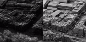
What is UrbanEyes 3D mapping?
UrbanEyes is a unique algorithm developed at NYU that embeds 3D information into images. The software is accessible via web browser and is compatible with all systems. To use the technology, your data of any size may be uploaded and processed through UrbanEyes. Once processed, the data is returned with multiple attributes embedded into the image for new layers of detail accurate within an inch! The processed images can be used to show multiple different attributes from temperature to dimensions of cracks in buildings, and supports complex queries such as neighborhood searches without delayed processing time. This technology provides a new level of detail for city planning, development and terrain specifications transforming physical work into a cost savings with reliable information gathering.